Sweat is running off my brow on the scorching hot runway on the air strip at Ngukkur, in the remote southern Arnhem Land region of the Northern Territory, with the shade cast off the wing of my chartered Censsna 210 providing the only relief from the sun. With temperatures in the mid 40’s, the tarmac reflecting the sun’s heat and the humidity of the NT’s notorious ‘build-up’ to the wet season the conditions were suffocating.
Soon was forgotten, however, when the Cessna’s propeller spluttered to life and vibrations of the engine reverberated through the aircraft’s fuselage. The aircraft surged forward and soon we were rattling down the runway with that trademark sense of weightlessness when the wheels of the plane finally lifted off from the tarmac. With the door’s off, to provide greater photographic opportunities, the wind buffeting soon provided the much-required relief to the heat and I was scanning the horizon for features in the landscape that may make interesting photographic subjects.

Before long one of the most incredible landscapes was unveiled 2,000 feet below me, we broad swathes of floodplains punctuated with twisted rivers, sprawling wetlands, endless patchworks of mangroves and endless intertidal seabeds that seemed to merge into the sky without horizon. This is truly wild and remote country and spectacular when seen from above.

For me, the sense of freedom of being in the air scanning the landscape for shapes, textures and forms is all-consuming and all sense of time is lost. I feel that aerial photography provides me with a unique perspective to explore my passion for photography, as what may seem ordinary from the ground can be extraordinary from above.
In November 2020, I was fortunate enough to charter a flight over the Limmen Bight region of the Northern Territory. The Limmen Bight Region is found in the south-west corner of the Gulf of Carpentaria, to the north is Arnhem Land, to the south is the Barkley tableland and to the west some 400km away is the headwaters of the Roper River at the famous springs of Mataranka.
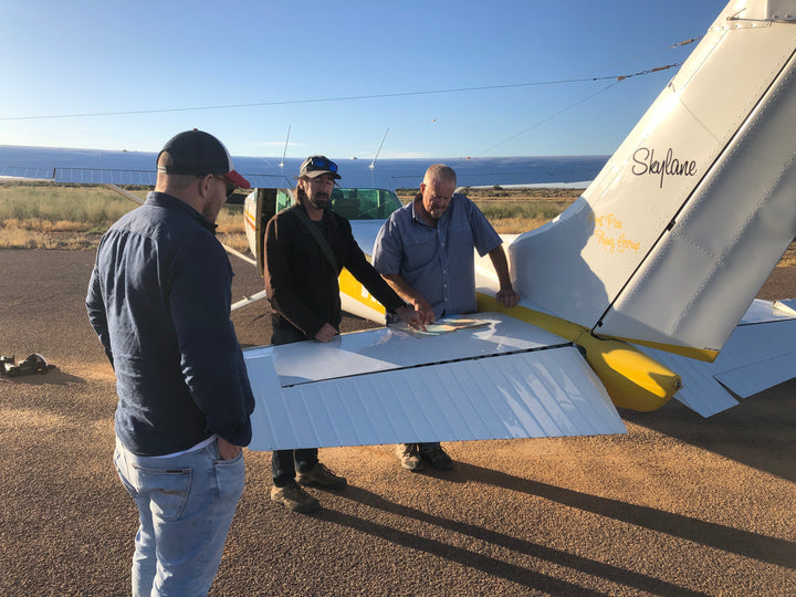
Even the best-laid plans sometimes go wrong. With COVID-19 resulting in state border closures and restricted travel between states, my plans for a flight over the region in August 2020 were foiled and it wasn’t until November 2020 I was able to resurrect my plans and make a mad dash to the NT to visit my sister and her family in Darwin. Having previously lived in Katherine for 4 years, my brother-in-law had a number of contacts around town. After a phone I received a text “Call Ben from Katherine Aviation, Roper River looks interesting”. Soon, I was hatching a plan with the helpful team from Katherine Aviation for a charter over the area.

The Limmen Bight area is approximately 350km from Katherine and after several conversations with the team at Katherine Aviation we came up with a flight plan that included two stops at Ngukkur, the closest airfield to the Limmen Bight area. The rough plan included a 4:00am alarm, a three hour drive from Darwin to Katherine, fly out of Katherine (the civilian air strip uses the same runway as RAAF Tindal, the Australian Airforce’s northern base currently undergoing AUD $8.0 billion in upgrade to infrastructure and facilities) to Ngukkur, prepare the plane for a photographic survey, return to Ngukkur, refuel and return to Katherine.
Ngukkur is the largest town in the Limmen Bight Region (formerly known as the Roper River Mission) and is situated on the Roper River, about 120km from the River Mouth. Ngukkur is home to approximately 1,000 permanent residents (1,149 at 2016 census) but swells at certain times of year with several small indigenous outstations also found in the region. The main language spoken in Ngukur is kriol, but s also home to a number of endangered languages including Alawa, Marra, Warndarrang, Ngandi, Ngalakgan, Nunggubuyu, Ritharrngu and Wägilak.

The Limmen Bight Region, which is found between Groote Eylandt in the north and the Sir Edward Pellew Group of islands in the south, is part of the traditional lands of the Marra, Yanyuwa, Alawa and Wandarrang peoples. There are two Aboriginal Land Trusts in the Limmen Bight Region: Arnhem Land located to the north of the Roper River and the Marra, located to the south of the Roper River and the north of the Limmen Bight River.
The Yugul Mangi Land and Sea Management Corporation, which manages a land area of 20,000 km2 in the Roper River basin, was established in 2008, although Yugul Mangi rangers have been operating since 2002 from Ngukkur. The Yugul Mangi rangers are responsible for fire management, weed management, feral animal management as well as the management of sites of cultural significance (sacred sites, art sites etc).
Like many remote indigenous communities, there is a thriving art scene at Ngukkur. However, given that Ngukkur is a melting pot of many different people’s there is not a singular style that people are following. There is no singular attitude or line of thought or trend. The nine language groups mean there are so many different painting styles. There are so many different thought lines and stories being told. What is common, however, is the use of bold colours in the paintings. This is something that I found particularly evident when flying over the region was that many of these colours and textures in the paintings are eerily familiar to the aerial perspective of the region.
The region’s climate is tropical, with the wet season generating most of the flows of the main rivers, flooding the coastal plain with freshwater and discharging nutrients into Limmen Bight. The tidal range of Limmen Bight is mesotidal, with the change from high to low tide between two and four metres. Combined with a shallow seabed, this creates the Territory’s second-largest area of intertidal flats when exposed at low tide.

Above: Highly saline floodplains create vibrant colours
Eucalypt woodlands with a grassy understorey dominant the inland parts of the bioregion, whereas closer to the shoreline there are saline tidal flats with samphire shrubland bordered by tall grass, as well as mangrove forests and patches of rainforest. Land subject to inundation and saline coastal flats are common, while a narrow band of foreshore flats follows the entire shoreline. Mangroves are found in the mouths of the Roper and Limmen Bight rivers and along the banks of creeks.
The tidal range in the south-west corner of the Gulf of Carpentaria ranges from 2-4 metres, creating vast mudflats and sandflats on the gently sloping seabed. The coastal floodplains and intertidal and foreshore flats of the Roper and Limmen Bight rivers dominate the hinterland of the Limmen Bight shoreline, while there are extensive mud and sand/mud intertidal flats at low tide. The intertidal flats merge with saline flats along much of the shoreline, interrupted by patches of mangroves and rainforest.
Rises in and sea surface temperatures, and increased intensity of storms and cyclones, have had significant impacts on the Limmen Bight Region. The recent mass dieback of mangroves in the Gulf of Carpentaria during the 2015-2016 summer affected 1,000 km from the Roper River to Karumba in Queensland, with 7,400 ha or about 6% of the Gulf’s mangrove systems dying as a result of the dieback, the largest single dieback event on record. Evidence of the mass dieback event was still apparent from above during my charter over the area.

Above: Swathes of dead mangroves from the 2016 dieback event
Photographing from the air can be tricky, and not only is rewarding but hugely enjoyable. Working out of an open window of a light aircraft or a doorless helicopter means dealing with some serious wind buffeting, wash from the propeller, high frequency vibrations from the engines and sometimes severe aircraft movements. As I move through the air, I find myself multi-tasking; from grappling with my equipment, dialling in the best technical settings on my camera, working to shoot powerfully composed images and keeping up with the rapidly changing perspective, all while communicating with the pilot to orchestrate the best flight path.

Above: Top-down abstract images of flood plains around the Roper River
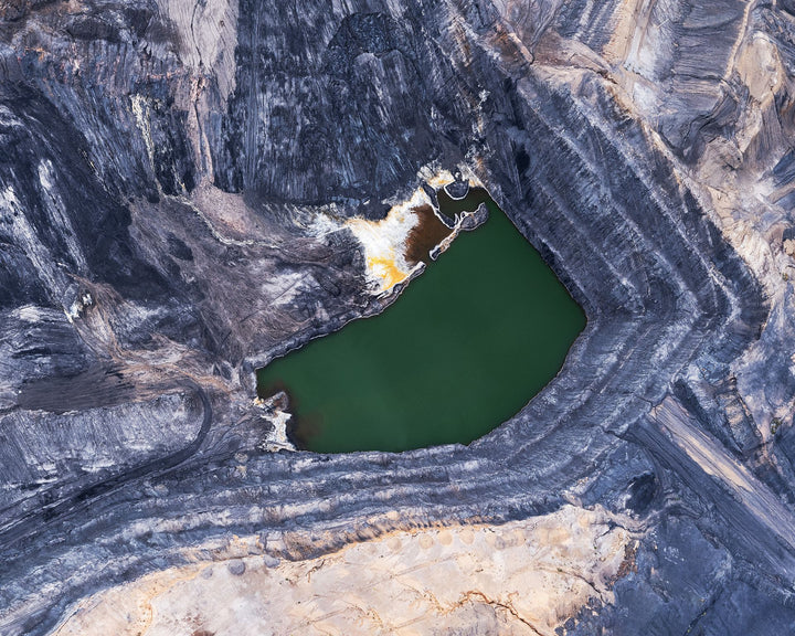
The essence of aerial photography - looking down from up high - is all about offering new insights into landscapes and surroundings, even from familiar scenes. For me, the most appealing aspect of aerial photography is the ability to look past the obvious and find interpretive meanings. Over the floodplains adjacent to the Roper River, the patterns left by drying water looked like infinitely complex fractal patterns. Similarly, over the Limmen Bight, the high salinity levels in the water gave off a myriad of colours with one pool looking like the flames of a fire.

Above: Fractal patterns across a vast floodplain
As a photographer, our ability to abstract the landscape is emphasised in aerial photography. In landscape photography, a horizontal line usually indicates the horizon, suggesting time and place by anchoring an image and creating depth. By angling the camera down, abstracting or often excluding the reference point of the horizon, allows me to focus on texture, pattern, shape, balance, contrast, and colour. Each of these key elements were on display in hyperreality over the Limmen Bight allowing for the perfect harmony between my love of geography and my love of art.
My charter over the Limmen Bight region of the Northern Territory opened my eyes to how thrilling it can be exploring remote and wild areas of the country – something I hope to do a lot more of.
The full gallery can be viewed here.